3 Majeure : Géosciences et Géophysique du Littoral
3.1 Semestre 1
3.1.1 Coastal hydrodynamics & morphodynamics
This course is part of the Coastal hydrodynamics & morphodynamics module
Teacher in charge: X. Bertin
Objectives
- To solve a problem represented by a simple differential equation (coastal erosion, dune migration, etc.) by means of the Finite Difference Method
- To master the basic problems related with numerical modelling (stability / Courant numbers, boundary conditions, convergence, etc.) ;
- To understand the limitations associated with a given software for a specific simulation ;
- To design a simplified model to simulate : (1) passive tracer transport and (2) wave propagation in coastal areas.
Course content
The aim is to explain the principles of numerical modeling in hydrodynamics, sedimentary dynamics and morphodynamics; to familiarize students with the basics of numerical schemes (precision, convergence, stability, dissipation and numerical dispersion) by illustrating them with applications to problems of morphodynamics, wave propagation and the transport of tracers in the coastal environment.
3.1.2 Python / Signal processing / Gegraphical Information System
This course is part of the Data analysis for geosciences 1 module
Teacher in charge: O. de Viron
Objectives
- interpret a simple algorithm written in Python
- write a simple algorithm including the basic structures: test, loop, I/O, assignment with case studies in geosciences
- import numerical data from the geosciences disciplines written in any format, ASCII and NetCDF, for computer processing
- explain how a measurement is converted into a series of digitized data
- explain what a Fourier transform is and give its properties
- write a code that computes the Fourier transform and represents it from a standard library (Numpy) with application to geophysical case studies
- explain the problems associated with a Fourier transform of a series of di-gitalised data, and identify the effects in a geophysical case study
- explain what a filter is, the different types of filters, and their actions on data with application to geoscience case studies
- write a program that filters a series of data with application to geosciences.
- master the use of GIS software commonly used in the professional world
- perform processing operations on vector or raster spatial data, in 2D or 3D
- design and produce cartographic documents
- write a Python program to produce geoprocessing and maps
- implement GIS tools adapted to the study of coastal environments
Course content
Programming with Python: the aim is to give students the basics of algorithmics. They will have to implement these principles for simple problem solving in geosciences; They will learn the basics of the syntax of the Python language in order to perform scientific computing.
Signal processing: this course aims at understanding and implementing the basics of signal processing which will be necessary, among others, for the instrumentation courses.
Geographical Information System: this course aims at understanding and implementing the basics of geographic information systems.
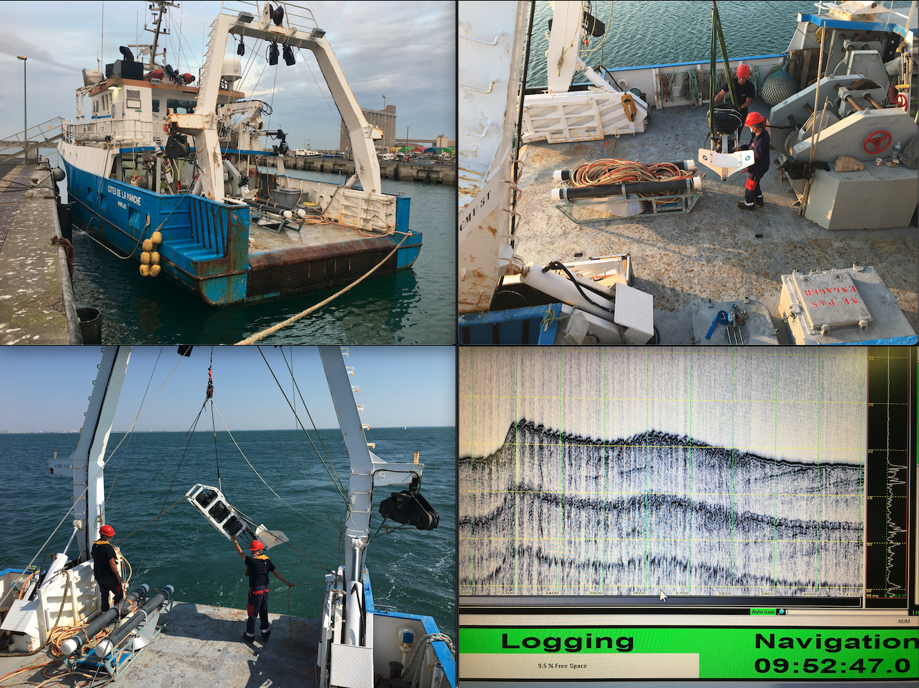
3.1.3 Marine geology and oceanography
This course is part of the Instrumentation in Geophysics 1 module
Teacher in charge: E. Chaumillon
Objectives
- To experience and understand measurements at sea ;
- To describe the functional principles of tools used in marine geology and geophysics as well as in coastal oceanography ;
- To apply imparted knowledge when developing sea measurement skills ;
- To acquire data, analyze their quality, and carry out relevant processing ;
- To edit and analyze processed data ;
- To assess the performance of different marine geology tools in order to gain insight on their limitations and benefits.
Course content
The aim is to provide students with the practical and theoretical bases for carrying out measurements in marine geology (positioning, bathymetry, lateral scanning sonar, seismic reflection) and coastal oceanography (current flow, measurements of agitation, sediment transport and turbidity).
The practical work takes place at sea, during an oceanographic campaign, aboard a vessel of the National Institute for Earth Sciences and Astronomy (INSU - CNRS): the Côtes de la Manche.
3.2 Semestre 2
3.2.1 Coastal sedimentology, geomorphology and stratigraphy
This course is part of the Coastal sedimentology, geomorphology, stratigraphy and solid Earth deformation module
Teacher in charge: E. Chaumillon
Objectives
- explain key concepts about the sedimentary record of sea-level variations, climate change, and human activities in coastal sedimentary environments
- observe, recognize and analyze sedimentary successions in a core sample
- observe, recognize and analyze the architecture of a sedimentary fill (incised valleys, sandbanks, coastal barrier) from seismic and radar data;
- observe, recognize and analyze coastal geomorphological changes using bathymetric and topographic data and aerial and satellite photos
- compare and classify the different types of incised valleys, sandbanks and coastal barriers.
Course content
The aim is to understand, be able to analyze and synthesize knowledge of sedimentology, geomorphology and stratigraphy of silico-clastic littoral sedimentary processes. A focus is made on the large coastal sedimentary accumulations which are protections or resources for human activities: incised valleys, sandbanks, coastal barriers.
3.2.2 Earth’s surface deformation & coastal impacts
This course is part of the Coastal sedimentology, geomorphology, stratigraphy and solid Earth deformation module
Teacher in charge: V. Ballu
Objectives
- To explain Earth surface deformation (concepts of rheology of the lithosphere, strain/deformation) and its underlying causes ;
- To introduce the concept of tectonic plates and its consequences in terms of vertical and horizontal deformation on the Earth’s surface, especially on the coastline ;
- To be able to define the concept of seismic cycle ;
- To explain tsunami formation, propagation and amplification mechanisms ;
- To place a particular coastline as part of a global context, in a geodynamic setting, in order to determine, to a first approximation, the natural hazards to which it is exposed.
Course content
Students will learn and understand the sources of the deformation of the Earth’s surface at different scales of space and time (tectonics, isostasis, loading effect, deformation of anthropic origin…). Particular emphasis will be placed on deformations representing a hazard for the coastal environment and the processes that generate these deformations.
3.2.3 Data analysis for geosciences
This course is part of the Data analysis for geosciences 2 module
Teacher in charge: O. de Viron
Objectives
- Define average, variance, probability law, normal distribution variable ;
- Demonstrate the central limit theorem and explain its application in geosciences ;
- Compare two means with the student’s t-test, or with more than two using the Analysis of Variance (ANOVA) F-test ;
- Use a Chi-square test to assess independence or distribution ;
- Calculate and test correlation between two data sets in a correlated noise ;
- Explain the relevance of non parametric statistical methods ;
- Design simple code to analyze data, by writing a Python script that reads data, performs a parametric or non parametric test, and/or least square fit, and provide the results in an intelligible way ;
- Interpret the results of non parametric tests ;
- Explain the underlying hypothesis of the Least Squares method ;
- Test the significance of the Least Squares model, and determine correlation and confidence intervals of the estimated parameters ;
- Constrain a Least Squares problem using linear methods.
3.2.4 Instrumentation in geophysics 2
This course is part of the Instrumentation in geophysics 2 module
Teacher in charge: F. Lévêque
Objectives
- identify the different components of a measurement acquisition chain
- adapt the sampling mesh of the measurement collection to the question asked
- use a radar survey device
- analyze radar survey data
- select the most appropriate geophysical survey method for the study problem
- Critique the results of a geophysical study in a coastal environment
Course content
The aim is to become familiar with physical measurement, to master the limits of a sensor, to adapt spatial sampling to the resolution of the information sought. Examples of application in prospecting, logging and analysis on sample in coastal area of magnetic, radar, electromagnetic and electrical methods.
3.2.5 Stage (de 6 semaines)
Cet EC fait partie de l’UE Stage
Responsable : G. Wöppelmann
Objectifs pédagogiques
S’insérer dans une structure, interagir avec l’ensemble des membres de l’équipe et être capable de travailler au sein de cette équipe. Mettre en œuvre ses connaissances pour répondre à la problématique/mission qui lui a été confiée. Produire des données, les traiter et les interpréter de façon adéquate. Rendre compte de son expérience au travers d’un rapport écrit et d’une présentation orale.
3.3 Semestre 3
3.3.1 Instrumentation in geophysics 3
This course is part of the Instrumentation in geophysics 3 module
Teacher in charge: G. Wöppelmann
Objectives
- detail the principles of measurement and processing in tide gauges, satellite radar altimetry, GPS and gravimetry;
- describe the realization of landmarks, in particular ITRS, from fundamental techniques (VLBI, SLR, GNSS and DORIS), and explain their interest and performances
- collect measurements in the field, process them, evaluate their quality, criticize the results of a study and interpret them in geodetic and geophysical terms;
- construct time series, evaluate the quality of observations and estimated parameters, express results in geodetic or hydrographic references relevant to the study problem, interpret their content (geophysical signal)
3.3.2 Modelling in hydrodynamics & morphodynamics
This course is part of the Modelling in hydrodynamics & morphodynamics module
Teacher in charge: M. Karpytchev
Objectives
-Process data from in-situ measurements (water height, waves, currents, etc…) ; - Generate a model mesh onto a finite element model grid ; - Choose and implement boundary conditions within a model ; - Use tidal and atmospheric forcing ; - Calibrate and validate a model with respect to observation data ; - Analyze objectively numerical results.
Course content
The aim is to understand the physical processes controlling the hydro-sedimentary dynamics of beaches (wave-induced circulation, infragravity waves, etc.) and coasts subjected to the influence of waves and tides (estuaries, sandy spits, etc.). Students will learn how to use modern software (TELEMAC and BlueKenue) to simulate tides, waves and coastal transport from bathymetric data and atmospheric and tidal forcings.
3.3.3 Sea level variations, extremes & coastal risks
This course is part of the Sea level variations, extremes & coastal risks module
Teacher in charge: L. Testut
Objectives
- explain the processes that cause sea level variations, especially extreme levels (tides, surges, seasonal effects, long-term elevation), and their historical evidence
- calculate tidal constituents from tide gauge observations (harmonic analysis), analyze the quality of the results, predict the tide and determine the sea level rise
- describe extreme water level distributions and estimate statistical parameters of associated laws
- Determine the different types of sedimentary records of extreme sea levels related to storms and tsunamis
- Explain how flood hazard plans are established and the legal principles of associated responsibilities
Course content
The aim is to provide theoretical and practical elements to understand the origin of hazards related to sea level variations, their development in coastal areas, their observation, their description, but also their modeling, forecasting and simulation.
3.4 Semestre 4
3.4.1 Stage (de 26 semaines)
Cet EC fait partie de l’UE Unités transversales
Responsable : G. Wöppelmann
Objectifs pédagogiques
S’insérer dans une structure, interagir avec l’ensemble des membres de l’équipe et être capable de travailler au sein de cette équipe. Mettre en œuvre ses connaissances pour répondre à la problématique/mission qui lui a été confiée. Produire des données, les traiter et les interpréter de façon adéquate. Rendre compte de son expérience au travers d’un rapport écrit et d’une présentation orale.